
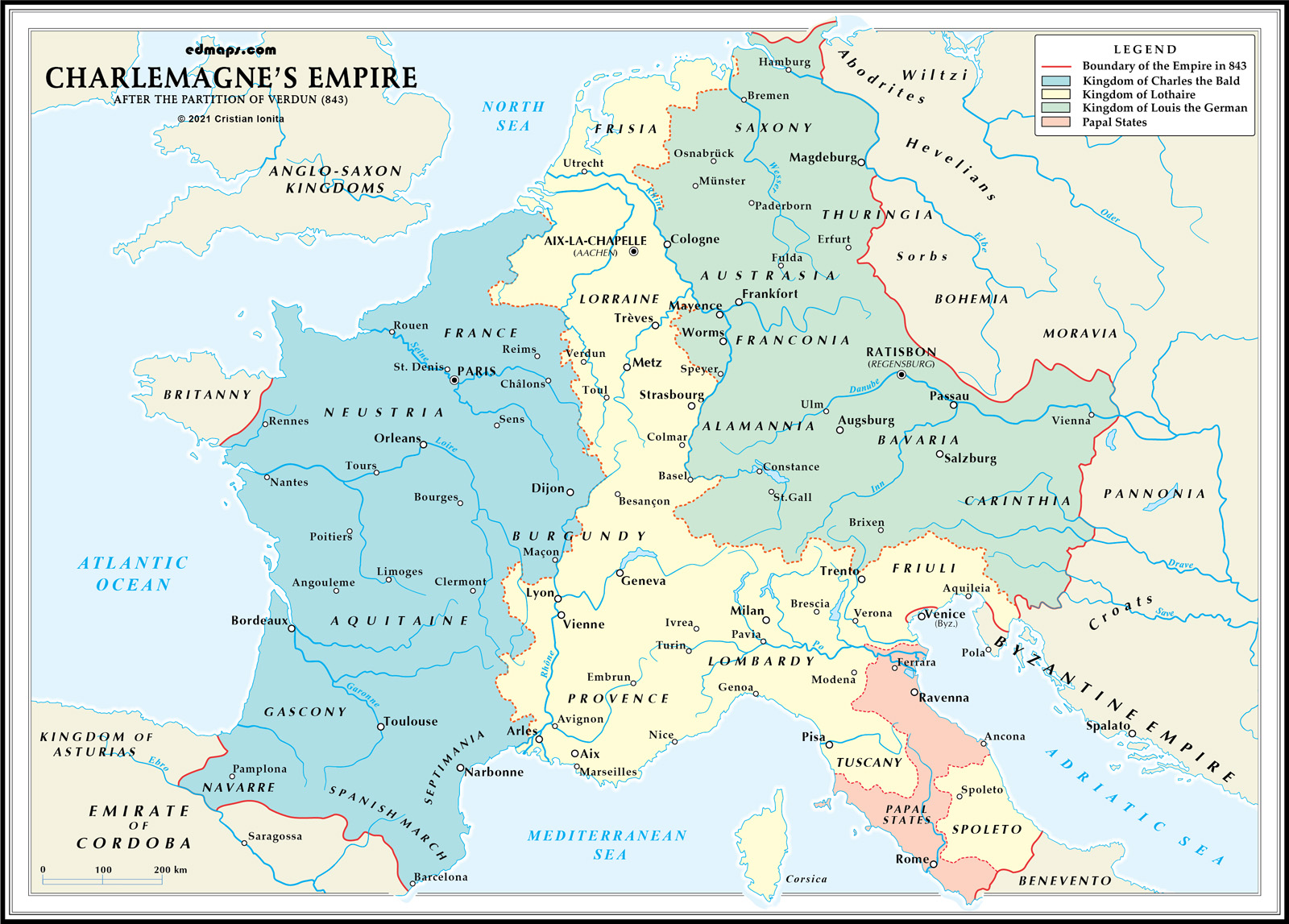
This page presents an original historical map illustrating the political landscape of the former Carolingian Empire in 843, following the Treaty of Verdun. Concluded among the grandsons of Charlemagne, the treaty divided the empire into three kingdoms, marking a turning point in European history and contributing to the emergence of political entities that would later evolve into France, Germany, and other medieval states. Designed for educational use, the map offers a clear visual representation of the territorial and political conditions that shaped Western Europe in the ninth century.
See also :
World History Maps — original world history maps (Europe, France, England, Italy, etc.);
Historical Maps of Europe — curated links to historical maps and resources covering European history;
Charlemagne's Empire in 814 — a map of the Empire at the end of Charlemagne's reign;
Europe in 1789 — a vintage map of Europe before the French revolutionary wars;
Europe in 1815 — a map of Europe after the Congress of Vienna.
Following Charlemagne's death in 814, his empire experienced immediate territorial and political fragmentation that culminated in the Treaty of Verdun (843), permanently dividing the Carolingian Empire into three distinct kingdoms.
Charlemagne's son Louis the Pious inherited the unified empire but faced mounting challenges from his own sons who demanded territorial divisions according to Frankish inheritance customs. The empire endured devastating civil wars (830-843) as Louis's sons (Lothair, Louis the German, and Charles the Bald) fought for territorial control, weakening central authority and inviting external invasions from Vikings, Magyars, and Saracens.
The treaty established three kingdoms based on linguistic, cultural, and strategic considerations. The Western Frankish Kingdom (Francia Occidentalis) went to Charles the Bald, encompassing present-day France west of the Rhône, Saône, and Meuse rivers. This territory contained approximately 2.5 million inhabitants speaking evolving Romance languages and would eventually become France.
Lothair I received Middle Francia (Lotharingia), a narrow corridor stretching from the North Sea to central Italy, including the imperial title and capitals of Aachen and Rome. This awkward territorial configuration included the Rhineland, Burgundy, Provence, and northern Italy. Louis the German obtained the Eastern Frankish Kingdom (Francia Orientalis), comprising Germanic-speaking territories east of the Rhine River, which would eventually evolve into the Holy Roman Empire.
Each kingdom developed distinct governmental structures adapted to local conditions. The division fragmented Charlemagne's administrative innovations, as counts, dukes, and bishops transferred loyalty to their respective kings. Central authority weakened significantly, accelerating feudalization as local nobles gained independence.
The Verdun division established the fundamental political geography of medieval Europe. Middle Francia proved unstable and was eventually absorbed by its neighbors, while the western and eastern kingdoms evolved into France and Germany respectively, creating enduring Franco-German territorial rivalry that would shape European history for centuries.
Sources, Methodology & Educational Use: The maps presented on this page are original creations produced for edmaps.com by Dr. Cristian Ionita. Each map is based on verified historical data relating to the territorial evolution, administrative structures, and political history of Europe. The maps are designed according to established practices in historical cartography, including source analysis, period contextualization, and visual clarity. The collection is curated to support teaching, learning, and public understanding of European history, and is intended for educational and non‑commercial use.
edmaps.com — Historical Cartography for Education
edmaps.com provides original maps and curated historical maps designed to support teaching, learning, and public understanding of territorial evolution and administrative history. The original maps are created by Dr. Cristian Ionita, and all curated maps are selected from public archives, historical collections, and private holdings, and are presented for educational and non‑commercial use.
© Cristian Ionita. All rights reserved.
Website: https://edmaps.com — Contact: info@edmaps.com


