
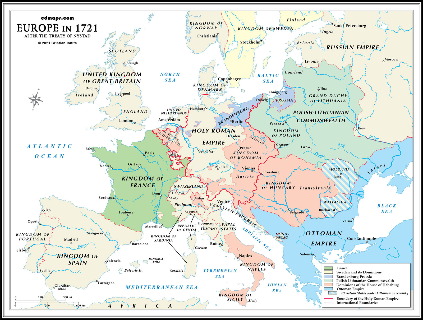
By 1721, Europe had experienced dramatic territorial and political realignment following the Great Northern War and War of Spanish Succession, fundamentally altering the continental balance of power and establishing new dominant states.
The Treaty of Nystad (1721) confirmed Russia's spectacular rise under Peter the Great. Russia acquired Swedish territories including Estonia, Livonia, Ingria, and part of Karelia, gaining crucial Baltic access and establishing St. Petersburg as its "window to Europe." This expansion made Russia a major European player, ending Sweden's Baltic empire and creating a new eastern power center.
France under Louis XIV had achieved territorial gains through the Treaty of Utrecht (1713), securing Alsace and maintaining influence over Spain through the Bourbon Philip V. However, the costly wars had strained French resources, while the emergence of Britain as a naval power and Austrian resilience checked French continental dominance.
Austria had successfully defended against Ottoman expansion, recapturing Hungary and parts of the Balkans through the Treaty of Passarowitz (1718). Austrian territorial gains in Italy, the Spanish Netherlands (now Austrian Netherlands), and southeastern Europe compensated for losses in western Germany and demonstrated Habsburg adaptability.
Sweden's defeat in the Great Northern War eliminated its status as a major power, reducing it to Scandinavia proper. Poland-Lithuania faced increasing territorial pressure from Russia, Austria, and emerging Prussia, foreshadowing future partitions.
The Ottoman Empire, after centuries of expansion, was increasingly on the defensive. Austrian victories in Hungary and the Balkans, combined with Persian conflicts and internal administrative challenges, marked the beginning of Ottoman territorial retreat from Europe.
Britain's naval dominance, confirmed through various Utrecht settlements, established British control over global trade routes and colonial territories, fundamentally altering the European power balance by adding maritime-commercial dimensions to traditional continental competition.


Sources, Methodology & Educational Use: The maps presented on this page are original creations produced for edmaps.com by Dr. Cristian Ionita. Each map is based on verified historical data relating to the territorial evolution, administrative structures, and political history of Europe. The maps are designed according to established practices in historical cartography, including source analysis, period contextualization, and visual clarity. The collection is curated to support teaching, learning, and public understanding of European history, and is intended for educational and non‑commercial use.
edmaps.com — Historical Cartography for Education
edmaps.com provides original maps and curated historical maps designed to support teaching, learning, and public understanding of territorial evolution and administrative history. The original maps are created by Dr. Cristian Ionita, and all curated maps are selected from public archives, historical collections, and private holdings, and are presented for educational and non‑commercial use.
© Cristian Ionita. All rights reserved.
Website: https://edmaps.com — Contact: info@edmaps.com


